You are not logged in

Distance
8.00 km
Elevation Gain
504 m
Type
Hike
Difficulty
Moderate
Estimated Time
4h
Route Type
Out & Back
Summit
Knockmealdown [Cnoc Mhaoldomhnaigh] (792 m)
Parking
Yes
Viewpoint
View on Google MapsKnockmealdown Loop — Directional Guide
Start: Bay Lough Car Park
- Head northwest up through the Glentaunemon valley, steeply uphill
- Climb Sugarloaf — hardest section of the hike
- From Sugarloaf, the ridge sweeps southeast — follow the Tipperary/Waterford county boundary wall along the spine
- Pass a small cairn marking Knockmoylan (slightly off the main ridge — continue past it)
- Follow the wall over 3 false summits (~300m of the 574m total gain)
- Reach the Knockmealdown trig point — main summit, 574m total elevation gain; views north into the bowl valley
- Return: descend and take the lower contour path back, avoiding re-climbing Sugarloaf, tracking back down to Bay Lough Car Park
Summary
- Start: Bay Lough Car Park (not the Vee road)
- Head northwest up Glentaunemon valley
- Climb Sugarloaf — steepest ascent
- Follow county boundary wall southeast along the ridge
- Pass Knockmoylan cairn (off-route, bypass)
- Summit Knockmealdown trig point
- Return via lower contour path back to car park
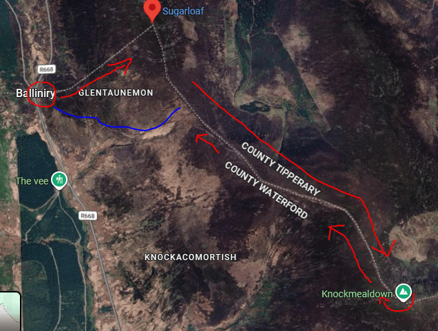
Route Map
More Hikes in Waterford

Coumshingaun to Mahon Falls
Dramatic Comeragh Mountains point-to-point linking the glacial corrie of Coumshingaun with the cascading Mahon Falls in Co. Waterford.


Comments:
Log in to leave a comment